EMA Cautions Residents, Motorists To Watch For Rising Water
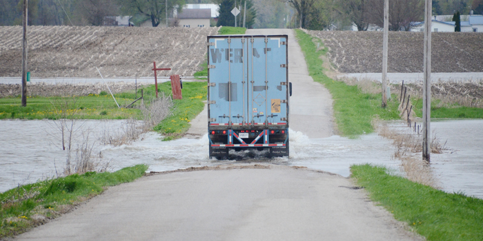
Motorists are advised to approach water on roadways with caution, such as this stretch on CR 200S, east of SR 19.
WARSAW — With forecasting of rain for at least the next four days, local experts are saying that water will only continue to accumulate and that residents in Kosciusko County should brace for pretty soggy conditions for the foreseeable future.
“We have seen more than four and a half inches of rain in the past six days,” said Kosciusko County Emergency Management Director Ed Rock. “This is after the ground is already saturated.”
 According to Rock, the majority of Kosciusko County drains into the Tippecanoe River, which has already filled the wetlands that normally take excess water.
“We are now in a position that we are dependent on the river’s flow to drain the water from our county,” Rock said. “The problem is that areas down stream are also full, so evacuation of our current conditions will be slow.”
According to Rock, one inch of rain on one acre of land equates to 27,154 gallons of water. “We have 343,040 acres in Kosciusko County,” he said. “This means that if we have 4.5 inches already on the ground we are needing to get rid of almost 42 billion gallons of water.”
According to the county’s highway department, no roads are yet closed in the county, but there are three locations where water is over the roadway and signs warning of high water have been put in place. Those locations are CR 550N, between CR 75E and CR 100E; CR 1350N between CR 200W and CR 750W; and CR 200S, east of SR 19.
“If anyone in Kosciusko county is in need of sandbags, sand and bags are available at the Kosciusko County Highway Garage on Old Road 30, east of Warsaw,” said Rock, who advised residents should bring their own shovels and manpower.
Wabash County
In nearby Wabash County, the National Weather Service of Northern Indiana issued a flood warning for Eel River in the vicinity of North Manchester, affecting Cass, Kosciusko, Miami, Wabash and Whitley counties.
At 2 a.m. Wednesday, May 1, the stage was 10.4 feet and rising. Flood stage is 11 feet. The river is now forecast to reach food stage later today.
Periods of showers and thunderstorms can be expected through tonight, with rainfall amounts of 1 to 2 inches possible.
Showers and thunderstorms will continue through Thursday, May 2, with locally heavy rain, as well as the possibility of strong thunderstorms. Many rivers will continue to experience high water levels into the weekend, according to the report.
The NWS advises motorist to never drive vehicles through flooded areas. The water may be too deep to allow safe passage. Residents are also cautioned not to allow children to play in or near flood waters.
Detailed river forecasts and more information can be found on the internet at www.weather.gov/iwx under Rivers and Lakes.
